Title" type="application/opensearchdescription+xml" rel="search"/>
Header
Search Results
Label
"Un mapa nuevo y preciso de México o Nueva España junto con California Nuevo México"
Label
Bowen, Emanuel, 1693 or 1694-1767 (cartographer / cartógrafo)
Label
1747-1752
Label
"America or the New World Map"
Label
Ortelius, Abraham, 1527-1598 (cartographer / cartógrafo) and Diesth, Aegidius Coppenius (publisher / editorial)
Label
1570
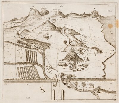
Label
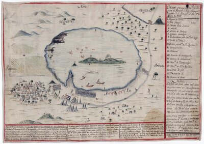
"Sketch or design that tries to give an idea of the River of San Juan de Nicaragua and the relation between the sites of the old and ruined Castle of San Juan and the new Fort of San Carlos"
Label
Alejandre Guerrero, José María (cartographer / cartógrafo)
Label
1781-03-26
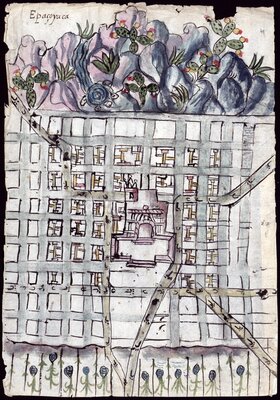
Label
"Plan for a city of Spaniards"
Label
Galicia Chimalpopoca, Faustino, -1877 (cartographer / cartógrafo)
Label
1855-12
Label
"Demarcation of new missions requested by the Franciscan fathers in New Mexico"
Label
Unidentified / No identificado (cartographer / cartógrafo)
Label
1746
Label
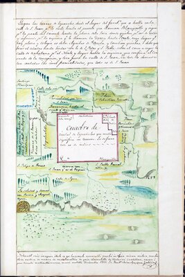
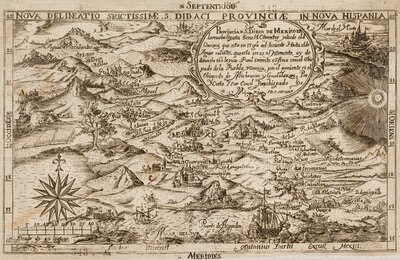
"Geometric Demonstration of a Large Cattle Site"
Label
Manrique de Zúñiga, Álvaro, marqués de Villamanrique, 1525?-1604 (author / autor) , Tovar Godínez, Luis de (contributor / contribuidor) , and Cuevas, Juan de (contributor / contribuidor)
Label
1589-07-10
Label
"Fort of Barrabas"
Label
Unidentified / No identificado (artist / artista)
Label
1818-09-30
Label
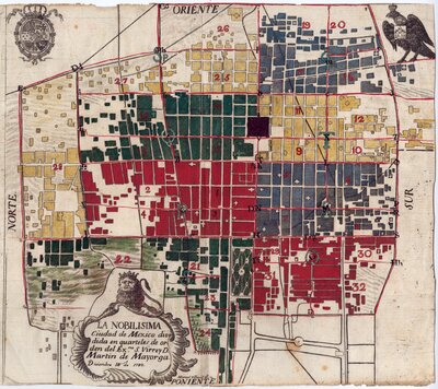
"The Most Noble Mexico City divided into quarters"
Label
Villavicencio, Manuel de, active/o 1762-1795 (cartographer / cartógrafo)
Label
1782-12-12
Label
"The most noble, and very loyal City of Angels"
Label
Unidentified / No identificado (cartographer / cartógrafo)
Label
1754
Label
"New Mexico and Florida"
Label
Sanson d'Abbeville, N. (cartographer / cartógrafo) and Somer, [unidentified] (engraver / grabador)
Label
1656
Label
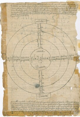
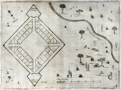
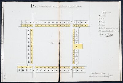
"Laws and measures of pueblos as disposed by His Majesty", diagram
Label
Isabel, Empress, consort of Charles V, Holy Roman Emperor, 1503-1539 (author / autor) , Vázquez, Juan (contributor / contribuidor) , Mendoza y Luna, Juan Manuel de, marqués de Montesclaros, 1571-1628 (contributor / contribuidor) , and García de Mendoza Moctezuma, Diego (contributor / contribuidor)
Label
1529-08-24
Label
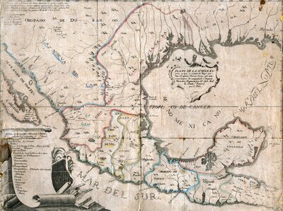
"Map of California, its gulf, and border provinces in the continent of New Spain"
Label
Peña, I. (engraver / grabador) and Venegas, Miguel, 1680-1764 (contributor / contribuidor)
Label
1757
Label
"Map of the Distinguished Town and Royal Collegiate of the Sanctuary of the Most Holy Mary of Guadalupe"
Label
Bonnard (artist / artista)
Label
Undated / Sin Fecha
Label
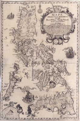
"Map of the Philippine Islands"
Label
Bagay, Nicolás de la Cruz, 1701- (engraver / grabador) and Murillo Velarde, Pedro, 1696-1753 (contributor / contribuidor)
Label
1744
Label
"Map showing the Yuriria Lagoon and Liceaga Island won from the Insurgents"
Label
Unidentified / No identificado (cartographer / cartógrafo)
Label
1812-11-01
Label
“New delineation of the Province of San Diego in New Spain”
Label
Isarti, Antonio (engraver / grabador) and Medina, Baltasar de, 1634-1697 (contributor / contribuidor)
Label
1682
Label
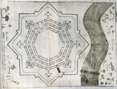
"Plan of the Presidio of Our Lady of Sorrows"
Label
F. Silverio (artista / artist) , Peña, Juan Antonio de la (contributor / contribuidor) , and Ortega Bonilla, Juan Francisco de (publisher / editorial)
Label
1722
Label
"Map of New Spain"
Label
Álzate y Ramírez, José Antonio (cartographer / cartógrafo)
Label
1769
Label
"Plan showing the projection of a new population in the new California"
Label
Córdova, Alberto de (artist / artista)
Label
1796-10-06
Label
"Presidio of Our Lady of Loreto in the Bay of the Holy Spirit"
Label
F. Silverio (artista / artist) , Peña, Juan Antonio de la (contributor / contribuidor) , and Ortega Bonilla, Juan Francisco de (publisher / editorial)
Label
1722
Label
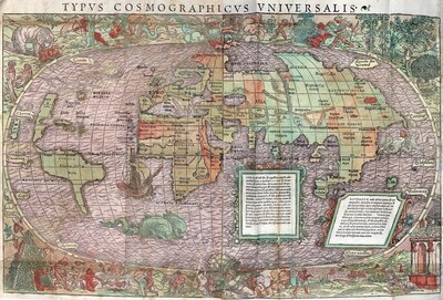
"Universal Cosmographic Type"
Label
Huttich, Johann, 1480?-1544 (contributor / contribuidor) and Grynäus, Simon, 1493-1541 (contributor / contribuidor)
Label
1537
Label
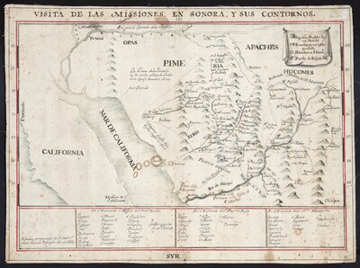
"Inspection of the missions in Sonora and its contours"
Label
Baltasar, Juan Antonio, 1697-1763 (cartographer / cartógrafo)
Label
1752
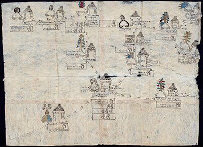
Translated Title:
Map of Santiago Tecali and its surroundings
Creator / Contributor:
Unidentified / No identificado (cartographer / cartógrafo) , Moctezuma, Joaquín de Francisco (contributor / contribuidor) , Muñoz, Benito (patron / patrocinador) , and Cueva, Francisco de la (scribe / escribano)
Date Created / Date Issued:
1584-09-07
Translated Title:
Map of the surroundings of Santiago Tecali and Tepexi de la Seda
Creator / Contributor:
Unidentified / No identificado (cartographer / cartógrafo) , Moctezuma, Joaquín de Francisco (contributor / contribuidor) , Muñoz, Benito (patron / patrocinador) , and Cueva, Francisco de la (scribe / escribano)
Date Created / Date Issued:
1584-09-07
Translated Title:
Map of the Tepexic de la Seda district
Creator / Contributor:
Unidentified / No identificado (cartographer / cartógrafo) , Moctezuma, Joaquín de Francisco (contributor / contribuidor) , Muñoz, Benito (patron / patrocinador) , and Cueva, Francisco de la (scribe / escribano)
Date Created / Date Issued:
1584-09-07
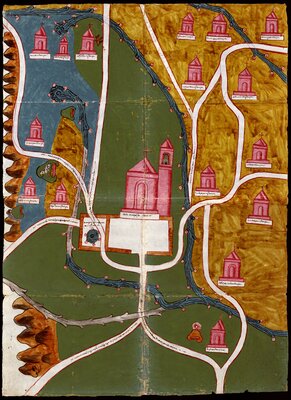
Translated Title:
Colored hand drawn map of the Virgin of Guadalupe shrine complex and its surroundings
Creator / Contributor:
Montes de Oca, José María, 1772-c. 1825 (artist / artista)
Date Created / Date Issued:
circa 1796-1805
Translated Title:
Pintura de Amoltepec
Creator / Contributor:
Unidentified / No identificado (cartographer / cartógrafo) and Cervantes, Hernando de (contributor / contribuidor)
Date Created / Date Issued:
1580
Translated Title:
Pintura de Cempoala
Creator / Contributor:
Unidentified / No identificado (cartographer / cartógrafo) and Obregón, Luis (contributor / contribuidor)
Date Created / Date Issued:
1580
Translated Title:
Pintura de Guaxtepec
Creator / Contributor:
Unidentified / No identificado (cartographer / cartógrafo) and Gutiérrez de Liébana, Juan (contributor / contribuidor)
Date Created / Date Issued:
1580
Translated Title:
Pintura de Misquiahuala y Atengo
Creator / Contributor:
Unidentified / No identificado (cartographer / cartógrafo) and Padilla, Juan de (contributor / contribuidor)
Date Created / Date Issued:
1579
Translated Title:
Pintura de Quatlatlauca
Creator / Contributor:
Unidentified / No identificado (cartographer / cartógrafo) and Vargas, Antonio de (contributor / contribuidor)
Date Created / Date Issued:
1579
Translated Title:
Map of the Virgin of Guadalupe shrine complex and its surroundings
Creator / Contributor:
Montes de Oca, José María, 1772-c. 1825 (artist / artista)
Date Created / Date Issued:
circa 1796-1805
Translated Title:
Painting of Acapistla
Creator / Contributor:
Unidentified / No identificado (cartographer / cartógrafo) and Gutiérrez de Liébana, Juan (contributor / contribuidor)
Date Created / Date Issued:
1580
Translated Title:
Painting of Cholula
Creator / Contributor:
Unidentified / No identificado (cartographer / cartógrafo) and Rojas, Gabriel de (contributor / contribuidor)
Date Created / Date Issued:
1581
Translated Title:
Painting of Epazoyuca
Creator / Contributor:
Unidentified / No identificado (cartographer / cartógrafo) and Obregón, Luis (contributor / contribuidor)
Date Created / Date Issued:
1580
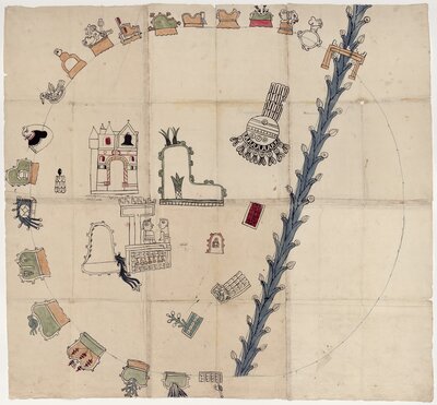
Translated Title:
Painting of Teozacoalco
Creator / Contributor:
Unidentified / No identificado (cartographer / cartógrafo) and Cervantes, Hernando de (contributor / contribuidor)
Date Created / Date Issued:
1580
Translated Title:
Painting of Tistla and Muchitlan
Creator / Contributor:
Unidentified / No identificado (cartographer / cartógrafo) , Martínez, Francisco (contributor / contribuidor) , and Bazán, Gonzalo (contributor / contribuidor)
Date Created / Date Issued:
1582
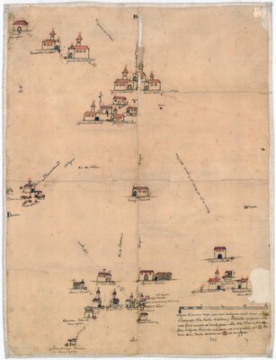
Translated Title:
Villages, missions, and haciendas south of the Rio Grande
Creator / Contributor:
Unidentified / No identificado (cartographer / cartógrafo)
Date Created / Date Issued:
1750