World War I

When (then) Lt. Fenton joined the Army, the United States entered the Great War and prepared for combat on foreign soil for the first time. While the Army did have mapmakers and draftsmen, they had not established mobile map printing or produced maps of Europe. They relied on maps created by the French Army and quickly set up means to overprint current strategic information to create situation maps. Many types of situation maps were used in World War I, from hand-drawn field maps to trench maps. The advances in cartography made during this period were as dangerous as the advances in weaponry. The very maps in the collection were used by infantry Lieutenant Fenton to lead a platoon of soldiers into combat. As such these documents were likely as valuable to him as his weapons.
Col. Fenton was awarded the second-highest military decoration for his valor in the Battle of Belleau Wood, located north of the frontline on this map.
FENTON, ROLAND T., Second Lieutenant, U.S. Army
Company B, 103d Machine-Gun Battalion, 26th Division, A.E.F.
Date of Action: July 18, 1918
Citation:
The Distinguished Service Cross is presented to Roland T. Fenton, Second Lieutenant, U.S. Army, for extraordinary heroism in action at Belleau, France, on July 18, 1918. Before daylight on the morning of July 18, 1918, when his command arrived at the jumping-off position, Lieutenant Fenton discovered that one platoon was missing. Not desiring to send his runner back through the heavy enemy barrage, Lieutenant Fenton turned his command over to another officer and with utter disregard for his own personal safety went to locate the missing platoon. Although knocked down and wounded by a bursting shell he found the platoon and guided it around the barrage to its position. Additional ammunition then being needed by his organization Lieutenant Fenton went through enemy shell fire a second time, arranged for ammunition, returned, and in spite of his wounds advanced with his command, refusing to be evacuated until it was relieved three days later.

Hand-drawn maps were common on the frontlines because the situation changed faster than Base Printing could produce and disseminate situation maps. The hand-drawn map to the left is a detail of a small commune northeast of Belleau on the Château-Thierry map above, both maps are from 1918. The map shows built areas, a railway line, roads, and vegetation.
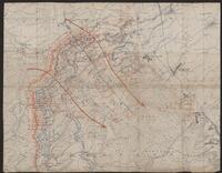
A perfect example of a field map, this composite map of the Meuse Department in France, consists of two segments of a French topographic map glued together. The French trenches and batteries were overprinted in red, with German trenches and batteries overprinted in blue by the U.S. Army 29th Engineers, Base Printing Plant. The overprint is distinct over the thin, black lines of the original lithograph map. As the legend indicates, other information on the map includes, troop movements indicated with red overprinted arrows; the French front line; strong points with dugouts; dugouts and occupied places; good trenches kept up and occupied; trenches having great activity; wire; postitions where nine or more have been observed; machine guns; minenwerfers; telephone exchanges; signal stations; Post of Command; battery positions active; O.P.'s; and munitions depots.
What makes this map even more interesting are the handwritten annotations with additional information between and perpendicular to the arrows representing troop movement.

This Long distance (indirect fire) firing range calculator for the Hotchkiss machine gun is the only chart in the collection.

The U.S. Army printed this map after World War I ended. The Allied Forces signed the ceasefire agreement with Germany on November 11, 1918. The anniversary of the signing of the armistice is now celebrated as Veterans Day in the United States, and Armistice Day in Europe.