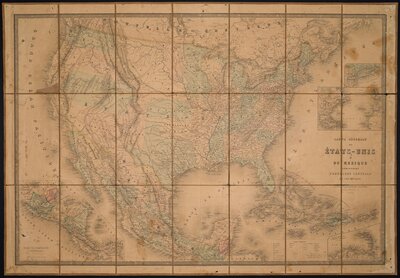
Mid 19th Century Foreign Interventions in Mexico brings together a rare set of historical maps documenting Mexico’s turbulent mid-nineteenth-century history. Drawn from the University of Texas Libraries’ Benson Latin American Collection, these materials include detailed portrayals of infrastructure and military defenses, reflecting both the perspective of a newly independent Mexico and the territorial and economic interests of the United States and France during their respective military interventions. Together, the maps illustrate how different nations and institutions visualized conflict, territory, and sovereignty through high-resolution digitized images.
As one of the largest collections of Latin American materials in the world, the Benson Latin American Collection is uniquely suited for researchers seeking a multifaceted perspective on this important and complex period of Mexican history. Although other online archives include maps of nineteenth-century Mexico, few focus on war-related cartography or on the contrasting perspectives between Mexican and foreign originators. Therefore, the Rare Maps Collection presence within the BLAC affords scholars the opportunity to look closer at this complex historical period and to analyze how mapping practices reflected shifting notions of sovereignty, empire, and national identity.
After gaining independence from Spain, Mexico entered a fragile period marked by economic precarity, political turmoil, and the lingering consequences of years of warfare. As Conservatives and Liberals fought to implement their divergent visions of an independent Mexican state, imperial powers in the region—namely the United States and France—saw an opportunity for expansion in the newly independent nation rich in natural resources.
This exhibit seeks to highlight maps depicting Mexican, American, and French territorial and military claims to explore both Mexican sovereignty as well as the position of Mexico in the cultural imaginary of imperialist nations of the period. In so doing, this exhibit reveals this history continues to reverberate in the present day, from highlighting historical United States interest in the Gulf of Mexico as a means to assert imperialist power over Central America and the Caribbean, to highlighting how Mexican maps could be used as a means to construct a national identity.