More Than Borders Shape Us


Maps visually express ideas and themes to be shared with others. They record history, preserve culture and traditions, as well as represent change and continuity over time. They use spatial relationships to communicate ideas, and often, the maker of a map can use these relationships to promote specific concepts. The maps in this exhibit invoke means of communication, preservation of genealogy, financial incentives, national identity and development, and foreign ambitions in nineteenth-century Latin America. These primary documents clarify how different countries and regions saw not only themselves, but how they saw each other. Through two of the maps in this exhibit, Colton’s 1856 Map of Nicaragua and the Map of Mexico, Guatemala, and the West Indies by Thomas G. Bradford, 1835, one can understand the ways outside perspectives shaped the global understanding of the Latin American region. They also illustrate foreign perspectives on Latin American affairs.The other three include information that demonstrates how certain countries used genealogical relationships, technology, and development to create a national identity. They illustrate the ways through which Latin American countries sought distinction and recognition as new, independent nations. These maps teach us how a country can display certain details about themselves to generate a national image, one that other groups and countries can understand and accept.

"Mexico, Guatemala, and the West Indies"
This map presents the geography of the Southern U.S., Mexico, and Central America through the eyes of the United States. American cartographer Thomas Bradford published this map in 1835, just one year before American settlers inTexas declared independence from Mexico. Bradford’s map sprawls across the Americas, from the southern United States to Panama. Note how “Austin’s Colony” of American settlers is shaded yellow, while the rest of Mexican Texas is colored in pink. Before the revolution, U.S. officials frequently lambasted Mexico’s incompetent management of border territories. The distinctness of “Austin’s Colony” indicates that Bradford saw Texas as an American entity. He published the map in Boston, Massachusetts – one of the rising giants of the U.S. publication industry. How might this map have influenced its American audience’s perspective on Texan Independence?

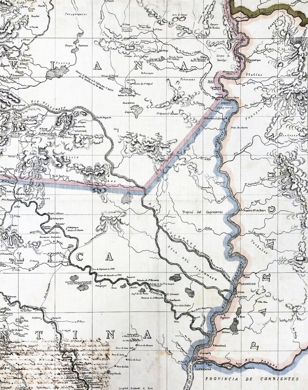
Topographic map of the intersection between Bolivia, Argentina, and Paraguay marking political borders
The brightly colored country boundaries in the center of this topographical map demarcate the borders of Paraguay, Argentina, and Bolivia. Drawn for the Colonel of Engineers of Bolivia, it likely helped Bolivian officials make decisions about development and construction. It is an engraving, and is about the length of your arm from shoulder to fingertip. This map contributes to the crucial understanding of national frontiers and landscapes in Latin America, and it provides context to the future border struggles between Andean nations. During this period,Bolivia and Paraguay entered into a border dispute over the Chaco region, which would not be resolved until the 1930s through military conflict. Part of the disputed region can be seen in this map, where it is drawn as part of Bolivia. Maps visually clarify how nations understood themselves in the broader landscape of a region, and this map, as it focuses on topographical features and borders, does just that. When examining the map, contemplate how borders shape a nation’s identity, and how border conflicts could be disastrous for a burgeoning, or fully-fledged, nation.

"Telegraphic Map of the Mexican Republic"
A lithographic map unfolds to be a spread of Mexico’s states across a three-foot page with each border emphasized by pastel watercolors. Etched in dark ink are the major telegraph lines that course through the nation like veins. Commissioned just one year after the rule of Benito Juarez, a Mexican president who served as a preeminent symbol of Mexican nationalism and resistance to foreign intervention, this map signifies the utility of communication in a time of political evolution. This object contributes to the critical understanding of the influence the government has over land as it actively searches for avenues of expansion and control.

"Genealogical Tree of the Hidalgo y Costilla Family, 1810-1910"
Family Tree of the Legitimate Descendancy of Emperor Moctezuma II, until 1878. Each black circle on this family tree represents an individual descendant of Emperor Moctezuma II, the last Emperor of the Aztecs. After Moctezuma’s concession to the Spanish crown, the heir to the Aztec throne, Doña Isabela, was christened and married to Spanish elites. Moctezuma’s descendants subsequently were exempt from indigenous taxation. Strategic marriages and successful litigation meant the descendants of Moctezuma gained noble positions as Dukes, Duchesses, Counts, Countesses, and Viceroys to the Spanish Crown.The tree includes family members from his daughter Isabel up until his latest living descendant as of 1878, when the piece was created. Like other maps in this exhibit, this genealogy offers a spatial representation of social relationships, yet does so over the span of generations. It reveals how the original ruling family of Moctezuma II transitioned into membership among New Spain’s elite.

"Major General William Walker"
Attached to William Walker’s first hand description of the War in Nicaragua, Colton’s 1856 map of Central America highlights a trade route through the Republic of Nicaragua that connects the Atlantic and the Caribbean through the San Juan River and Lake Nicaragua. In a time predating the Panama Canal and an intercontinental railroad, control over this route that connected New York City to San Fransisco created significant economic incentive. American business magnate Cornelius Vanderbilt was granted first control over the trade route. When William Walker, an American filibuster from Tennessee, took over control of Nicaragua from 1856-1857, he sparked a feud with Cornelius Vanderbilt and his one year tenure as Nicaragua’s president ended with his surrender to the United States’ Navy. Through Colton’s map, one can see the significance outsiders played in coining the term “Latin America”, as expressed through Gobat.